NFHAP: Mackeys Creek Gulf Coast Strain Walleye Habitat Restoration
| Project Start Date | |
|---|---|
| Project Leader | |
| Organization |
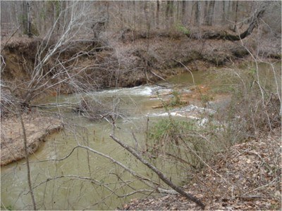
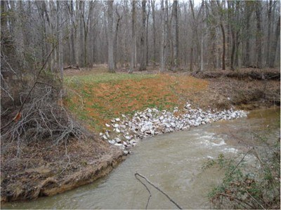
The initial phase of a project to restore a Gulf Coast strain of walleye (Stizostedion vitreum) population which had been in decline since the 1970s, was undertaken on a headwater stream of the Tombigbee River. The goal was to improve the spawning and rearing habitat by stabilizing a section of stream bank and to stop a head cut from advancing upstream. (Photo: Mackey's Creek Habitat Restoration Project Site)
Partner(s): Mississippi Department of Wildlife, Fisheries & Parks Natural Resources Conservation Service US Fish & Wildlife Service
Description of Site:
- The stream bank had washed out due to downstream modifications of the stream channel.
-
Over the long term, restoration will result in about 7 miles of restored habitat.
Problem:
- Existing habitat compromised populations of crystal darter, Alabama hog sucker, southern sand darter, Tombigbee darter,
rock darter, freckled darter, and spotted bass as well as walleye. -
Degraded habitat did not support spawning or juveniles.
Strategy:
- Construct an 80-ft long rock dike and backfill to restore the natural slope.
- Seed the bank and plant willows to prevent erosion.
- Place washed gravel in the adjacent shoal to create a potential spawning site.
- Stock with hatchery-reared fish.
The on-the-ground restoration is completed. In Phase II, an adjacent waterfowl pond will be renovated for use as
a grow out pond for fingerlings. Fish and habitat monitoring are
currently being conducted.
Complete
Associated Locations
| Town | zip code | county | state | congressional dist |
|---|
Barriers
| Name of barrier | Latitude | Longitude | FONS ID | FIS Project ID | FWS Acc. # |
|---|
Document Actions
